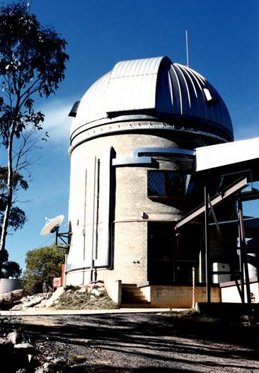
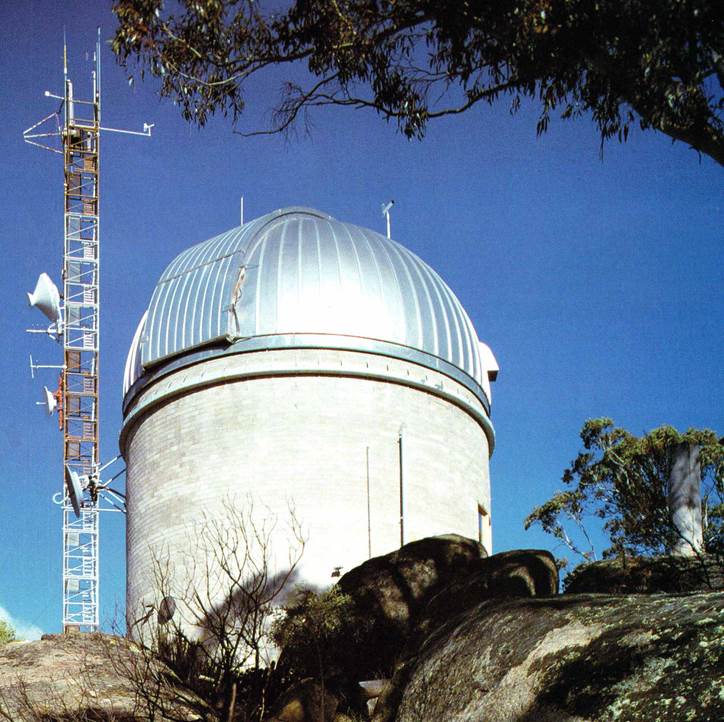
National Mapping’s Astro-Geodetic Observatory at Orroral
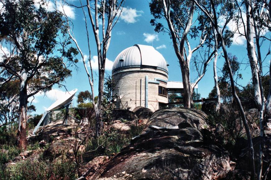
National Mapping’s Astro-Geodetic Observatory at Orroral circa 1980s
Introduction
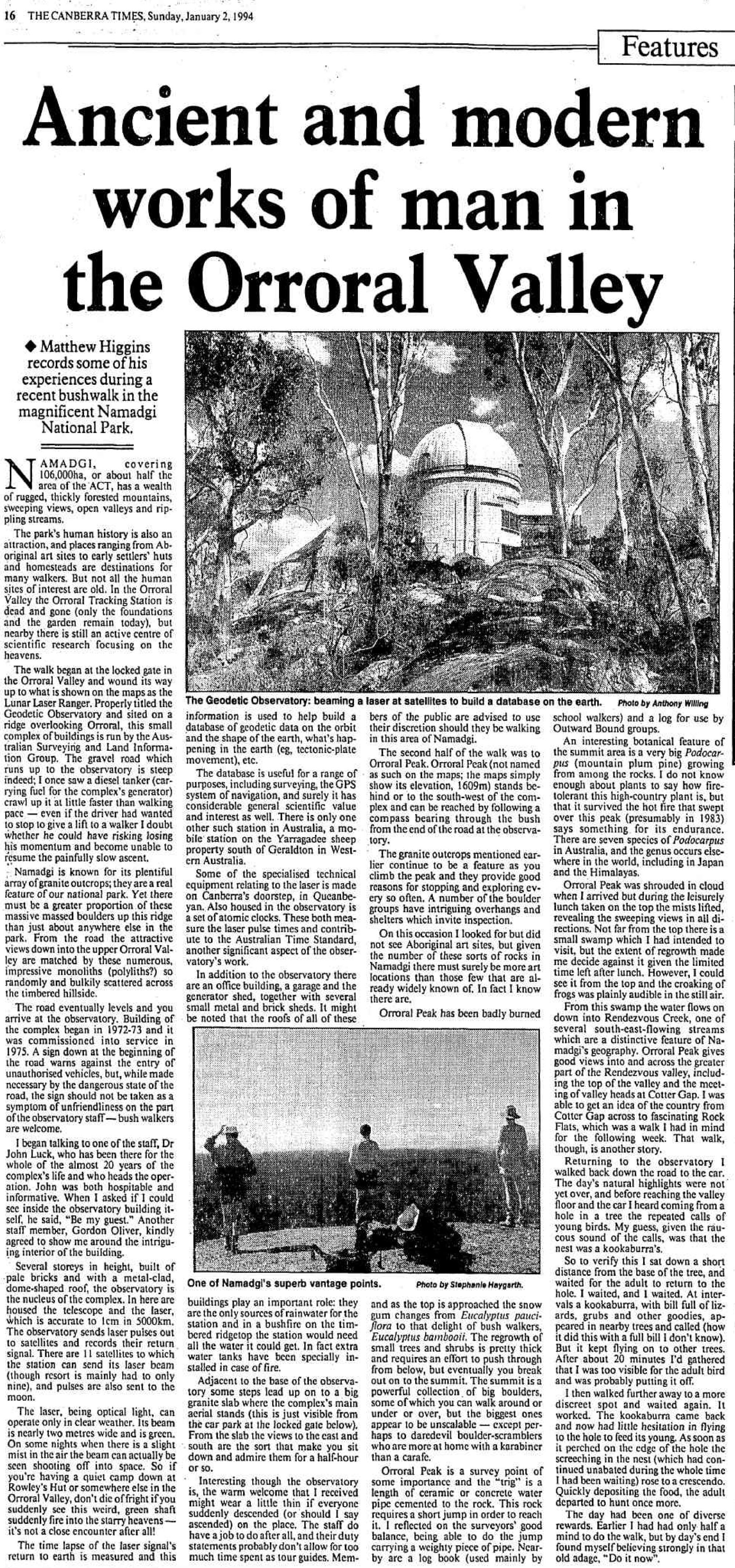
Within the Namadgi National Park of the Australian Capital Territory, some 60 kilometres south of Canberra city is the Orroral Valley. In 1965 the valley became home to the Orroral Valley Space Tracking Station. The Orroral Valley Space Tracking Station formed part of the National Aeronautics and Space Administration (NASA) Spacecraft Tracking and Data Acquisition Network (STADAN). As a result of international cooperation, in 1974, National Mapping’s later named Orroral Astro-Geodetic Observatory was also sited in the valley.
The NASA Orroral tracking facility became obsolete and was closed in 1985. Due to excessive vandalism the site was later bulldozed! The Nat Map Orroral Astro-Geodetic Observatory operated until 1998, and after that the site was reduced to just the structure. The structure and site were heritage listed by the Australian Capital Territory Heritage Council in 2016, so today the observatory shell is a curiosity and refuge for bushwalkers.
Closely associated with the Orroral Astro-Geodetic Observatory, before and during its years of operation, was the Mount Stromlo Observatory. Functions located at Mount Stromlo could well be regarded as a local driver for the establishment of the Nat Map Orroral Observatory.
In this article the drivers behind the establishment of Nat Map’s Orroral Observatory will be detailed, as well as the building’s design, operations and finally its heritage listing.
Mount Stromlo
Mount Stromlo is only some 12 kilometres from Canberra’s city centre. In 1914, Thomas Alexander Vance (1882–1959) as part of the geodetic survey of the then new Federal Capital Territory, established a new survey beacon on the then Mount Strom later Mount Stromlo. Just prior to that in 1911 the Oddie telescope had been installed nearby in a building recognised as the first Commonwealth building constructed in the newly established Federal Capital Territory, later the Australian Capital Territory.
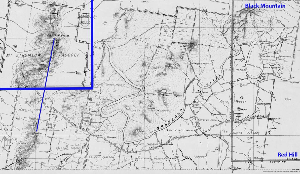
Section of a 1913 topographic map of the then Federal Capital Territory showing a prominence named Strom (area enlarged for clarity) in relation to Red Hill and Black Mountain; note the spelling in Mt Stromlow Paddock (courtesy National Library Australia : nla.obj-366138852).
The Oddie 9 inch refractor telescope had been donated to the Government in 1909 by amateur astronomer James Oddie (1824-1911), to assist in the creation of a Commonwealth Solar Observatory. The Commonwealth Solar Observatory was formally established in January 1924. It became the Commonwealth Observatory in 1945 with Dr Richard van der Reit Woolley (later Sir Richard van der Reit Woolley OBE FRS, 1906-1986) appointed the Commonwealth Astronomer. Previously in 1939 Woolley had had the term solar dropped from the observatory’s title indicating the observatory taking a wider role in stellar astronomy.
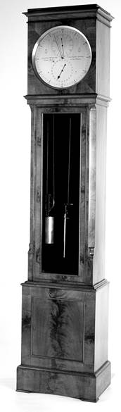
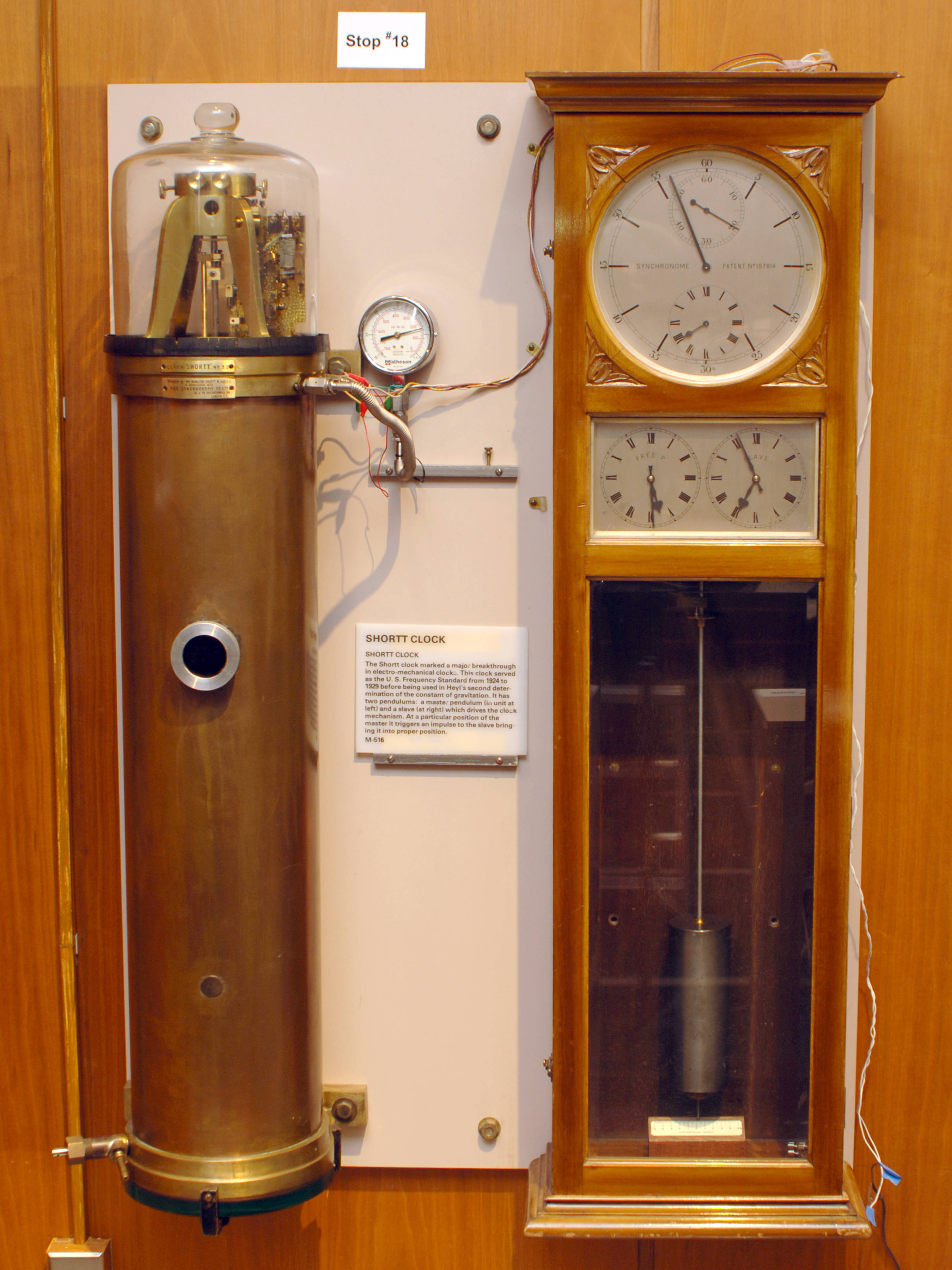
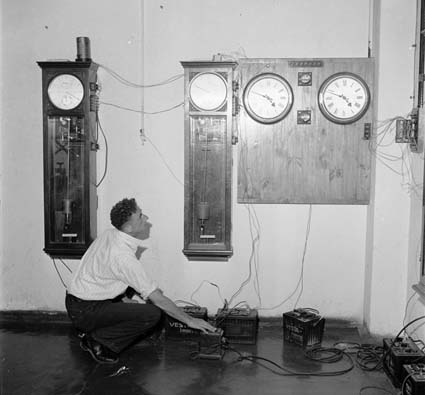
Mount Stromlo’s first timekeeper was a Shortt Synchronome free pendulum clock. This clock was the basis of a local time service which began in 1927. The Shortt Synchronome free pendulum clock, commonly just Shortt clock, was invented in 1921 by British railway engineer William Hamilton Shortt in collaboration with horologist Frank Hope-Jones, and manufactured by the Synchronome Co Ltd, London, UK. Between the 1920s and the 1940s, after which mechanical clocks were superseded by quartz time standards, the Shortt clock was considered the most accurate electromechanical pendulum clock commercially produced. About 100 of these clocks were produced between 1922 and 1956. Their stated accuracy at that time of around a second per year made these clocks vital worldwide for use in astronomical and naval observatories, in scientific research, and as a primary standard for national time dissemination services (in 1984 this accuracy was found to be well underquoted as described below).
Shortt clocks kept time with two pendulums, a master pendulum swinging in a vacuum tank and a slave pendulum in a separate clock, which was synchronized to the master pendulum by an electric circuit and electromagnets. The clock owed its accuracy to the slave pendulum being attached to the timekeeping mechanisms of the clock, thus leaving the master pendulum virtually free of external disturbances. This photograph of Shortt Synchronome clock No.32 is courtesy of the US National Institute of Standards and Technology.
Shortt clock No.41, preserved at the US Naval Observatory, was optically compared to the rate of an atomic clock for a month in 1984; modern optical sensors detected the precise time of passage of the pendulum without disturbing it. Pierre H Boucheron later reported the results of his study finding that the Shortt clock was stable with an equivalent error rate of one second in 12 years, far more accurate than the 1 second per year originally quoted. His data revealed the clock was so sensitive it was detecting the slight changes in gravity due to tidal distortions in the solid Earth caused by the gravity of the Sun and Moon.
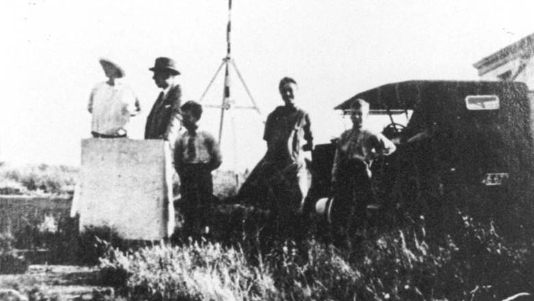
Mount Stromlo trigonometrical station (left) behind the Duffield Family at the site for the Oddie Telescope (Mt Stromlo Archives circa 1910) and 2019 photograph (right) of the trigonometrical station with fenced off remnant of Oddie Telescope dome left (courtesy Rod Menzies).
In 1944 it was decided that the national time service should be disseminated from Mount Stromlo in the national capital and the applicable equipment was moved from Melbourne to Mount Stromlo to be operated by the Commonwealth Observatory. The broadcasting of a time service from the Melbourne Observatory was to cease in June 1945. The Melbourne Observatory in the Domain had opened in 1862 and soon after it had become responsible for keeping Victoria’s time service. From 1865, the timekeepers were a pair of eight day, long case, astronomical regulator clocks, by Charles Frodsham, London, Nos.1062 and 1865. They were weight driven, with dead beat escapement and a mercury compensation pendulum. The Frodsham No.1062 and the then recently installed 8 inch Transit Telescope, purchased from the London firm of Troughton & Simms, were used to set Standard Time for the Colony of Victoria from 1883. In 1870, a telegraph wire was erected between the Observatory and the city centre and used to control a clock at the watchmaker Thomas Gaunt's shop in Bourke Street and later clocks at the railway stations at Spencer Street and Flinders Street, the Post Office, Parliament, Customs House and several banks. A master clock at Spencer Street sent an impulse every hour to clocks at other stations on the main passenger lines. Accurate time helped ensure that the railways operated safely, and railway time became an important source of accurate time for the whole community.
The development of radio technology provided a new means to disseminate time. From September 1913, the Melbourne Observatory joined the Wireless Time Service established by the International Time Association, and a series of time signals were transmitted at noon and midnight from a radio station in the Domain. At first this time service was primarily used by ships at sea. With the development of commercial radio in the 1920s, however, the hourly time signals became a familiar sound to the whole community and became available to anyone who could receive them. Shortt Synchronome free pendulum clocks No.5 and No.59 were acquired by the Melbourne Observatory in 1925 and 1933 respectively. Together with the Transit Telescope these clocks then became the basis for timekeeping for Victoria. (The Shortt Synchronome clock No.5 was transferred to the then Post Master General (PMG) Research Laboratories in 1945, which took over Victoria's civil time service, and in 1955 this clock was transferred to the PMG in South Australia, where it was used until 1968).
The Frodsham No.1062 and the Shortt Synchronome No.59 clocks were moved from the Melbourne Observatory to Mount Stromlo in 1944. It would appear that Melbourne’s Troughton & Simms, 8 inch Transit Telescope, was offered for sale and without a buyer then offered to the Astronomer Royal during his visit to Australia in 1947. After installation in England it was only used briefly in 1978 before being returned to Australia that same year. Its components are today housed by Museums Victoria. The Astronomer Royal, while in Canberra in February 1947, said that for three months last year (1946) the Royal Greenwich Observatory tested clocks at the Mount Stromlo Observatory by means of wireless signals. These tests showed that Australian time was inaccurate by one tenth of a second but this error had now been corrected.
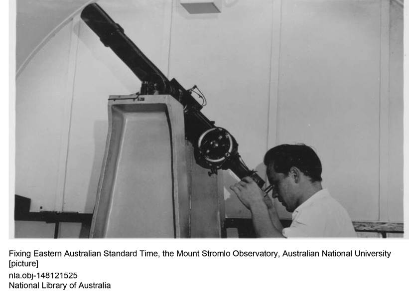
The National Time Service when it began at Mount Stromlo in 1944 was thus based on two Shortt clocks and an old survey telescope on an alt-az (altitude–azimuth) mounting. The telescope was modified with new optics and rebuilt as a reversible transit instrument.
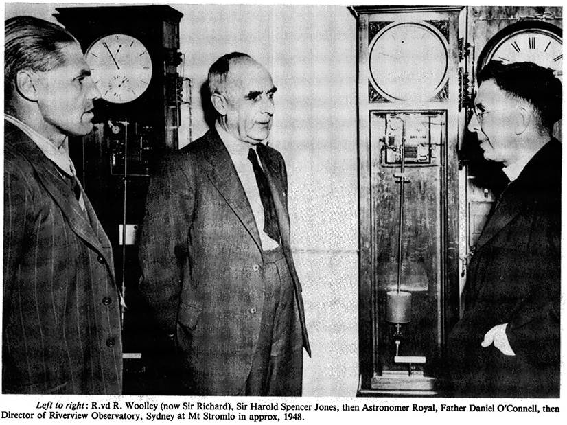
Sir Harold Spencer Jones, then Astronomer Royal, visited Mount Stromlo in 1947 according to newspaper and other reports.
Note the various clocks on the wall and those in this photograph.
In May 1946, the then Commonwealth Astronomer, Dr Richard van der Reit Woolley, stated that:…arrangements were nearly complete to broadcast time signals generated on Mount Stromlo through the naval wireless station at Belconnen, in the Australian Capital Territory [now HMAS Harman the Royal Australian Navy base that serves as a communications and logistics facility, it was established in the late 1930s as the Royal Australian Navy Wireless/Transmitting Station Canberra]. Approval had been given for the purchase of a quartz clock and a photographic zenith tube, with which it would be possible to keep time to the nearest millisecond.
For whatever reason not all of Woolley’s aims were immediately realised. It was reported that the communications facilities and relays for the quartz crystal oscillators for the National Time Service were established during 1948-49 but the realisation of a Photographic Zenith Tube was still some years away. As at 1953, time keeping determinations at Mount Stromlo were made with a 3 inch Transit Telescope aided by nine quartz crystal oscillators distributed between Canberra, Sydney and Melbourne. By mid 1963, the Mount Stromlo clock ensemble was given as four quartz crystal oscillators and a precision pendulum.
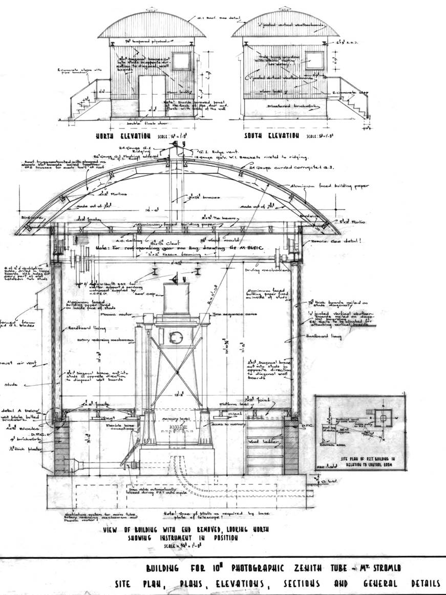
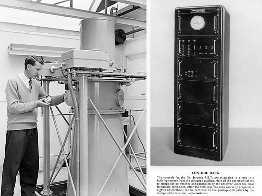
It was not until 22 June 1954 that tenders were called to erect a timber and steel building for the Photographic Zenith Tube (PZT) at Mount Stromlo. The building had to accommodate an instrument with a one metre base secured in the bedrock and that stood around three metres high. The roof had to slide open to allow the night sky to be photographed and the walls had to contain vents which when opened allowed rapid temperature equalisation of the building’s interior with the outside air temperature. The control console was to be housed in an existing nearby building, and not far away was the wooden hut erected in the 1940s to house the 3 inch Transit Telescope which was later removed in the early 1960s. It was not reported until 1955, however, that a 10 inch Photographic Zenith Tube from Grubb Parsons & Company Ltd, England was being acquired.
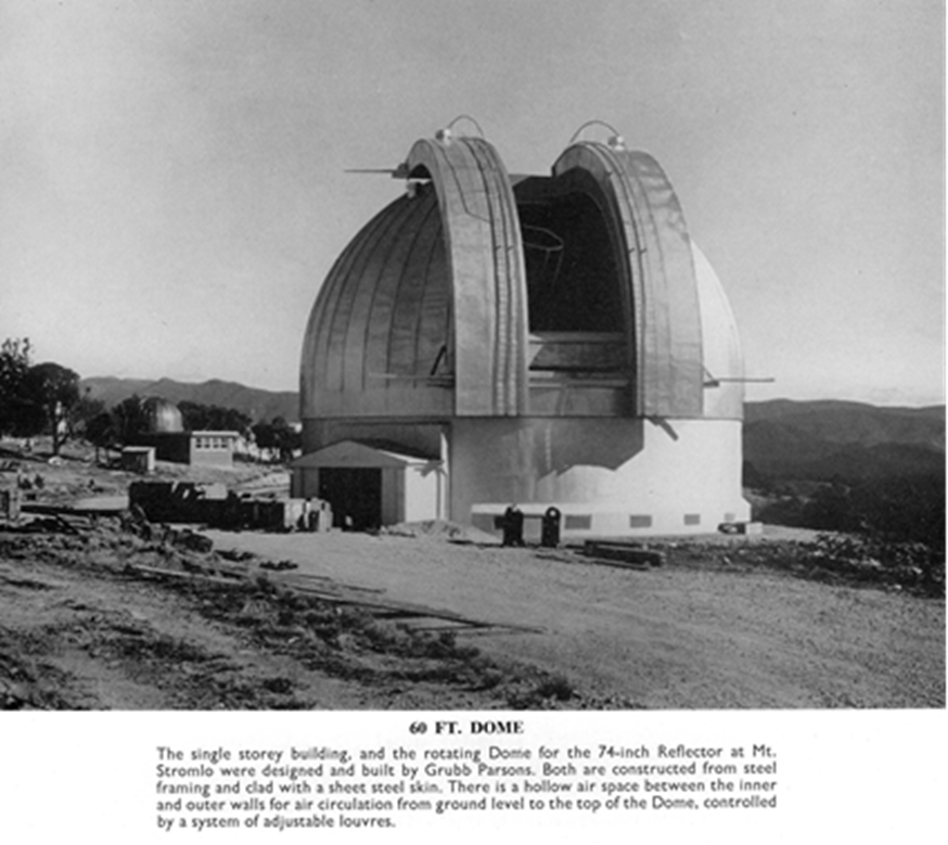
Grubb Parsons, more formally called Sir Howard Grubb Parsons & Company Ltd, England, showed the 10 inch Photographic Zenith Tube for Mount Stromlo under manufacture in their company publication Astronomical Instruments of 1956. (In November 1898, optical instrument maker and inventor Sir Howard Grubb had addressed the Royal Dublin Society and proposed the concept of a radio controlled clock. After many years of working with astronomical observatories, Grubb had developed a strong interest in timekeeping). It is understood that manufacture of the Photographic Zenith Tube for Mount Stromlo commenced in 1954 and was completed in 1955. The Mount Stromlo Photographic Zenith Tube was the third to be made; the first Photographic Zenith Tube was manufactured in 1954 for the Neuchatel Observatory in Switzerland; the second in 1954-55 went to the Royal Observatory at Greenwich. The Grubb Parsons’ publication also showed their designed and built facility under construction at Mount Stromlo for the 74 inch telescope also made by Grubb Parsons in 1955. Please refer to Grubb Parsons’ photograph below.
The Photographic Zenith Tube was brought into regular use at the Mount Stromlo Observatory from March/April 1957. A 1958 report however, stated that the Photographic Zenith Tube at Mount Stromlo did not at first operate without difficulties. Apart from mechanical and electrical faults a problem was discovered in the adjustment of the components of the objective. Analysis showed that that wear on the lens seatings during delivery was the root cause.
Please refer to the section below for more on the Photographic Zenith Tube and Photographic Zenith Tube photographs at the end of this article.
The Commonwealth Observatory was then part of the federal Department of the Interior. The Department had had responsibility for the functions of Astronomy, Geodesy, Lands and Survey and the Solar Observatory since its creation in April 1932. Most of these functions had been the responsibility of the earlier Department of Home Affairs formed after federation. The Commonwealth Observatory was later formally amalgamated with the Australian National University (ANU) on 1 January 1957. The ANU had been established in 1946 and with the observatory’s administration moving from government to academia the observatory could not retain the term Commonwealth in its title. The now named Mount Stromlo Observatory became part of the ANU’s Department of Astronomy in the Research School of Physical Sciences. In the late 1960s the ANU also gained control of the Siding Spring Observatory and began operating the two as integrated observatories. The 1957 amalgamation was somewhat reversed when on 27 September 1971 the Division of National Mapping, then in the Department of National Development, took over administration and operation of positional astronomy and time service activities from the Australian National University. The Positional Astronomy Section of the Mount Stromlo Observatory, became part of the Geodetic Astronomy Section in Nat Map's Geodetic Branch.
1954 photograph of the Commonwealth Observatory at Mount Stromlo showing the location of the Transit Telescope (blue line, right background) was used for regulating the clocks of the time service. The 1961 photograph below now shows the Transit Telescope along with the Photographic Zenith Tube hut (blue lines, right) constructed around 1955 (after GML Heritage, 2015).
Associated with this transfer to Nat Map was the continued operation and maintenance of the Photographic Zenith Tube and the responsibility for the maintenance and dissemination of time for Australia. Specifically, the maintenance of an atomic time standard, determination of Universal Time (UT), and the recording of latitude variation. Such data were important to the national and international communities. Thus, this information was being regularly transmitted to the Bureau International de l'Heure (BIH-International Bureau of Time in Paris) and the International Polar Motion Service (IPMS). These data were used for relating to other time and frequency standards in Australia and overseas, measuring variations in the rotation of the earth, and for investigations into continental drift.
International Cooperation
The determination of Earth orientation parameters like pole coordinates and time, came from visual, optical astro-geodetic observations by the international community. Up to the 1950s, visual observations using optical zenith telescopes were coordinated by the International Latitude Service, established in 1899, and Bureau International de l’Heure, established in 1911. Subsequently, the installation of stationary Photographic Zenith Tubes automated the earlier visual observation procedure. The Photographic Zenith Tubes operated within the framework of the International Polar Motion Service, established in 1962. Later modern space geodetic techniques like Very Long Baseline Interferometry, Satellite Laser Ranging, Lunar Laser Ranging and GPS were combined for monitoring Earth rotation by the International Earth Rotation and Reference Systems Service. The space geodetic techniques had replaced the optical astrometric methods by the end of the 1980s.
In parallel with the above, around 1955, the United States Smithsonian Institute Astrophysical Observatory (SAO) had accepted a national challenge to create a worldwide satellite tracking network. This decision established the SAO as a pioneer and leader in space science research. Between 1957-1961, the SAO and the United States Air Force Project Space Track, shared observations and ephemerides throughout the early days of satellite tracking. To further this work, the then USA's Smithsonian Institute for Space Tracking set up an Orroral valley complex in 1963, with limited tracking operations commencing in 1965 while equipment installation was completed.
As also part of the National Aeronautics and Space Administration’s (NASA) STADAN communications network, Orroral and other stations were important to the success of space exploration programs including the Apollo program to put a man on the Moon, and the Mercury, Mars, Jupiter and Saturn missions. The Orroral Valley Space Tracking Station operated until NASA consolidated its Australian Capital Territory activities at Tidbinbilla, and their Orroral tracking facility became obsolete and was closed in 1985.
During this same era Australia signed a treaty with the United States of America for scientific and technical co-operation on 16 October 1968. The treaty was designated the Hornig treaty in recognition of Donald Frederick Hornig (1920–2013) an American chemist, explosives expert, teacher and presidential science advisor. Hornig was a group leader in the Manhattan [Atomic Bomb] Project and in 1957 became a member of the National Academy of Sciences and the same year moved to Princeton University. Prior to the assassination of President John F Kennedy in 1963, Kennedy had announced Hornig as the presidential science advisor. Under the umbrella of the Hornig treaty, in March 1973, National Mapping and NASA formally agreed to cooperate in the construction of a Lunar Laser Ranging (LLR) facility in the Orroral Valley. The new Nat Map facility however, would be constructed on the valley side at a higher elevation to that of the SAO and STADAN tracking station.
The facility would enable the monitoring of the secular changes in position that occur as a direct result of : variations in the rotational speed of the earth and its inclination, commonly referred to as polar motion; crustal motion, commonly referred to as continental drift, and possibly long term changes in gravitation, tidal coupling and the variation of astronomical constants.
The United States agencies involved required that the Lunar Laser Ranging facility be located in Australia for geodetic reasons. A study of the geology of Australia showed that the Australian Capital Territory was a suitable location. It was recognised very early on that placing the laser ranging facility in reasonable proximity to the Mount Stromlo Photographic Zenith Tube would provide a unique opportunity for comparing two entirely different techniques in measuring polar motion and, indeed, continental drift, while similar comparisons against Very Long Baseline Interferometry would be feasible if the laser ranging facility was close to radio telescopes which existed at tracking stations in the Australian Capital Territory. National Mapping’s general interest in earth satellite tracking by Doppler methods and foreseeably by laser satellite tracking reinforced the desirability of the Australian Capital Territory as a site.
The need now to proceed with a Lunar Laser Ranging facility coupled with the relatively newly acquired positional astronomy and time service activities now coalesced into what was to become Nat Map’s Astro-Geodetic Observatory at Orroral.
The Astro-Geodetic Observatory at Orroral :
the site and building
The site for Nat Map’s Orroral facility was selected only after an assessment of factors including the site having at least 50% of nights suitable for operations; less than 10 millimetres of precipitable water vapour; more than adequate logistical support being available; zero night sky contamination and atmospheric stability contributing to a minimal variation in the optical refractive index (quickly indicated visually by no/minimal twinkling of stars). What was then known as the Orroral Valley collimation tower area was the site chosen in May 1973. The area was then part of the NASA Satellite Tracking and Data Acquisition Network (STADAN) facility at Orroral Valley. The collimation tower was being used to calibrate the tracking antennae of the facility. The tower and associated structures were removed around 1985 when the NASA tracking facility in the valley was closed. Thus, the collimation tower only appears in early photographs of the Orroral Observatory environs.
By November 1973, all necessary approvals had been obtained from the appropriate government departments, and the area surrounding the selected rock area had been cleared of those trees which would have interfered with observations and access. The top of the rock was also cleared of weathered material preparatory to construction of the domed building. The Bureau of Mineral Resources 1974 report by GB Simpson titled Lunar Laser Ranger Site, Orroral Valley, ACT : Foundation Investigation – 1974, may be viewed via the hyperlink.
The building was constructed under contract by the then Australian Department of Works. Standing 25 feet high the cylindrical shell was of double brick with a 28.5 feet external diameter, surmounted by a standard hemispherical dome ordered from the United States. The aluminium observatory dome was supplied by United States manufacturer Ash Dome. The aluminium sheets for the dome were up to 30 feet in length and were ferried, not without difficulty, to the observatory site by Natmappers using a Nat Map RLCH model Bedford 4 wheel drive truck. Construction of the dome was then completed by Natmappers overseen by the American representative.
The interior comprised three floors; ground, intermediate and observation. The observation floor contained the telescope, control console and laser pulse forming networks. The intermediate floor was airconditioned as it housed the control computer and its principal peripherals, the National Mapping atomic clock ensemble for time service activities, VLF receivers and associated electronic equipment, working space and room for the installation of control racks for future geodetic instruments. The ground floor accommodated the loading bay, heavy power and air conditioning plant, and staff facilities.
Essential to the internal building was the set of three 18 inch piers for supporting the telescope legs. To ensure firmness and stability, the piers were sunk four feet into the rock, and tied by 14 inch concrete beams just below each floor, including the ground floor. However, each pier was mechanically isolated everywhere from the building shell by neoprene filled gaps so that no vibrations induced in the building by wind or other movement were transmitted to the telescope.
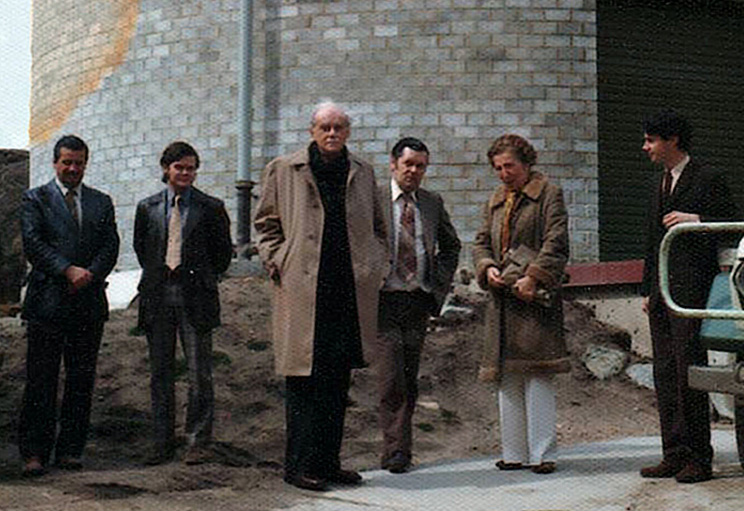
Photograph of Friday 5 September 1975, at Nat Map’s Orroral Astro-Geodetic Observatory; (as annotated on the back of the photograph by Klaus, L-R) Natmappers Klaus Leppert and Dr Ben Greene, Professor Paul Adrien Maurice Dirac, Dr JL (Len) Hughes from ANU (who was working with lasers at the time), Margit Dirac, and Dr Andrew Sinclair (affiliation undetermined); (courtesy Kathy Ellerman, Klaus Leppert’s daughter).
Construction of the observatory's main structure began in 1974 and it was occupied by Nat Map the following year. Soon after occupation by Nat Map, Orroral had an important visitor. In August/September 1975, Paul Adrien Maurice Dirac, then professor of physics at Florida State University in Tallahassee was in Australia to give a series of five lectures at the University of New South Wales. In 1933 the renowned British physicist had shared the Nobel Prize in Physics with Erwin Schrödinger in 1933, for the discovery of new productive forms of atomic theory. In commemoration of this visit, since 1979 the Dirac Medal for the Advancement of Physics has been awarded annually by the University of New South Wales jointly with the Australian Institute of Physics. On his way to Australia Professor Dirac, accompanied by his wife Margit, visited the lunar laser ranging observatory in Hawaii and as shown in the above photograph he also visited Nat Map’s laser ranging facility.
To relate the laser ranging results to the Australian geodetic network and provide data to enable local crustal movement to be separated from general tectonic plate movement (continental drift), during 1975 fifteen Geodimeter (Model 8) lines, totalling 295 kilometres, were measured in the Lunar Laser Ranger Horizontal Control Network. This first order network was centred on Nat Map’s Orroral facility and extended 40 kilometres in all directions. In addition, the Orroral Valley Vertical Control Network was largely established. This network required the construction of 14 bench marks, 57.1 kilometres of one way check levelling, 159.8 kilometres of two way, third order levelling and 79.4 kilometres of first order levelling. The levelling interconnected Nat Map’s laser ranging facility with the SAO/NASA STADAN Orroral Valley tracking station, the then US Jet Propulsion Laboratory’s (JPL) Deep Space Net antennae at Honeysuckle Creek and Tidbinbilla and the Photographic Zenith Tube at Mount Stromlo. Photographs of some of this work from 1975, may be viewed via this link.
From 1975 on periodic check surveys for monitoring vertical movement of the Lunar Laser Ranger facility, were carried out.
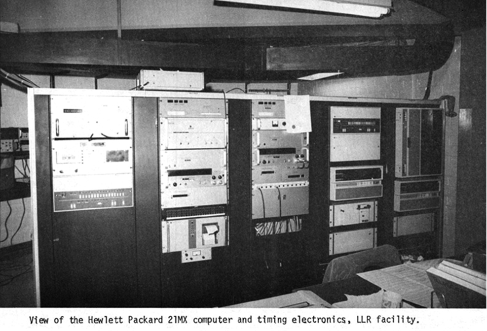
Photograph after Pearlman (1977), the computer was purchased by National Mapping.
the laser ranging equipment and activity
The Orroral laser ranging equipment was made available to Nat Map as a long term loan from NASA in cooperation with the Smithsonian Institute Astrophysical Observatory. Previously, the equipment had been operated by the US Air Force, Cambridge Research Laboratories (AFCRL) at Mount Lemmon in Arizona. Michael Pearlman’s 1977 report Support of Lunar Laser Ranging System in Australia, prepared for the National Aeronautics and Space Administration, provides other background and details of the earliest activities at Orroral.
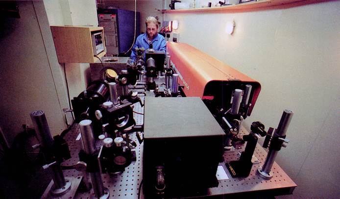
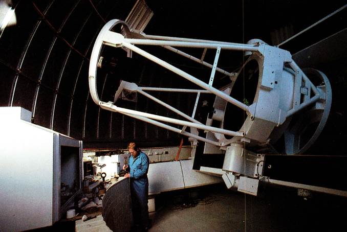
The main components of the Lunar Laser Ranger itself were a 150 centimetre Ritchey-Chretien telescope used in the modified Cassegrain (Nasmyth) configuration, a one Gigawatt pulsed ruby laser, a minicomputer for telescope and laser control and data acquisition, and associated control electronics. Operationally, a laser pulse of three nanoseconds duration was fired through the telescope which limited the pulse’s divergence. The pulse impinged on one of the retroreflectors placed on the Moon's surface by the Apollo astronauts and returning energy was collected by the telescope. The detected return energy stopped a nanosecond counter started by the outgoing pulse. It took about 2.5 seconds for the laser pulses to flash across the 385,000 kilometres separating the Earth from the Moon and back again.
The equipment was upgraded in 1981 under a contract with NASA, to include ranging to artificial satellites. In 1984, the first observations to the LAGEOS satellite were taken. The LAser GEOdynamic Satellite (LAGEOS) was designed by NASA and launched on 4 May 1976. A passive satellite with no power, communications, or moving parts, LAGEOS operations consisted simply of the generation of the orbit predictions necessary for the earth ground stations to acquire and track the satellite. It was the first spacecraft dedicated exclusively to high precision laser ranging and provided the first opportunity to acquire laser ranging data that were not degraded by errors originating in the satellite orbit or satellite array. LAGEOS-2, based on the original LAGEOS design, was built by the Italian Space Agency and launched on 22 October 1992.
The now Natmap Laser Ranging System (NLRS) routinely operated ranging to both satellite and lunar targets. The advantage that the upgraded system now brought Nat Map was the cost-effective meeting of present and future requirements in space geodesy. This advantage was illustrated by two developments during 1985-86; the cessation and closure of the Mount Stromlo Photographic Zenith Tube made redundant by the new laser technology and a no cost upgrade during 1985-86 of the Natmap Laser Ranging System itself to meet new requirements, from 5 centimetre to 1 centimetre single shot precision. The system was now capable of being further upgraded to meet expected future demands for higher accuracy. Nevertheless, deficiencies in the system were still being identified such that in 1990 new arrangements were put in place to upgrade the ranging system and make it suitable to be even more adaptable to technology changes in the future.
An Agreement being in respect of a project to develop Laser and Control Systems Upgrade to Orroral Laser Ranging System between Electro Optic Systems Pty Ltd (EOS) and the then Industry Research and Development Board (IRDB) of the Commonwealth Department of Industry, Technology and Commerce was signed on 23 March 1990. On the same day, a corresponding Agreement for Collaborative Research and Development of Laser and Control Systems Upgrade to Orroral Laser Ranging System between Nat Map and EOS was signed. Under these Agreements, the research and development costs were shared between the three parties according to a standard IRDB formula, with Nat Map having the option to purchase the prototype ranging system for its residual value upon successful demonstration of its capability. IRDB involvement was directed towards fostering export oriented Australian high technology industry.
The old 1974-81 era ranging system was decommissioned on 6 March 1991 with the now Orroral Laser Ranging System (OLRS) accepted to be operational from 1 January 1992. The final payment to EOS for purchase of the residual prototype system was made in June 1992.
The functions of Nat Map’s Orroral Observatory, were relocated to Mount Stromlo in November 1998. Various obsolete structures and equipment at the Orroral Observatory site including a cabin for workers, sheds, water storage tanks and thick cables were then removed leaving just the shell. The 8 tonne Orroral telescope was inched back down into the valley and dispatched to White Sands, New Mexico, USA, for use by NASA.
The History of Satellite Laser Ranging in Australia may be read via this link, and John Luck's 1990 paper titled Performance of the Upgraded Orroral Laser Ranging System is also available via the hyperlink. Photographs of the Astro-Geodetic Observatory may be viewed at the end of this article.
As mentioned above, responsibility for the maintenance and dissemination of time for Australia was transferred to Nat Map from the Australian National University in 1971. In 1967 Mount Stromlo had received its first caesium standard (Hewlett Packard 5060A Cs 205) which replaced its quartz crystal oscillators of the late 1940s. The quartz crystal oscillators had in turn replaced the earlier ex-Melbourne Observatory Frodsham No.1062 and the existing Shortt pendulum clocks. The first portable caesium clock (Hewlett Packard 5061A Cs 590) in Australia arrived in 1972 and was based at Mount Stromlo. In 1974 a third caesium standard, on loan from NASA (Hewlett Packard 5061A Cs 153) as part of the laser ranging package, was put into service by Nat Map.
The portable clocks were battery powered and were used to provide a direct check in time and frequency with the United States Naval Observatory master clock. The portable clocks travelled in style; always by air as much as possible and always with their own seat on the aircraft; the seat was located close to the kitchen bulkhead so that a cable could be run to a power socket in the kitchen, enabling the clock to receive aircraft power in flight! The first recorded visit by a commercial atomic standard to Australia had occurred in 1959, followed by another visit in 1967. Thereafter flying clock measurements were conducted on a regular basis until February 1986.
|
Clock type and accuracy evolution |
|||
|
Clock Type |
Regulator |
Year introduced (#) |
Equivalent timing uncertainty for 1 second (&) |
|
Sundial |
Relative motion of the sun |
3500BC |
Not applicable |
|
Pendulum |
Pendulum |
1656 |
12 hours |
|
Chronometer by Harrison |
Pendulum |
1761 |
1 week |
|
Shortt-Synchronome pendulum |
Master & slave pendulums |
1921 |
1 year (*) |
|
Quartz crystal |
Quartz crystal |
1927 |
50 years |
|
Rubidium gas |
Rubidium atom |
1958 |
5000 years |
|
Caesium beam |
Caesium atom |
1952 |
3 million years |
|
Hydrogen maser |
Hydrogen atom |
1960 |
5 million years |
|
The scientific age of the earth is around 5 billion years and we now can measure time accurate to 1 second over that period. An optical clock in development would be accurate to 1 second in 14 billion years or longer than the universe has been around. |
|||
|
Note (#) : may vary in different sources. Note (&) : indicative only; may vary in different sources. Note (*) : before 1984 comparison which gave 1 second per 12 years |
|||
With the completion of the Orroral building, in October 1974 three caesium clocks from Mount Stromlo were installed at Orroral by the United States Naval Research Laboratory. Soon after satellite time transfers began, providing sub-microsecond comparisons with the United States Naval Observatory and the Royal Observatory at Greenwich. In April 1977, Nat Map received an additional standard (Hewlett Packard Cs 1109) on loan from the US Naval Research Laboratories. The clock ensemble at Orroral then consisted of four caesium and three rubidium standards: Cs 153, Cs 205, Cs 590 (portable), Cs 1109, Rb 255, Rb 311 and Rb 322. All seven of Nat Map’s atomic clocks were then read and compared hourly by computer and satellite time comparisons with United States Naval Observatory were also made by computer. (The caesium clocks were best for long term time keeping in contrast to the rubidium clocks which were better for short term time keeping.) A second portable caesium clock (Hewlett Packard Cs 1708) was later acquired.
One clock was designated as the national primary standard of time and was maintained with the objective of keeping Australian time accurate to 100 nanoseconds (a nanosecond is one billionth of a second thus 100 nanoseconds is 1/10 000 000 of a second). Harold Lyons 1958 paper Atomic Clocks, not only describes the various types of atomic clock, but also contains photographs of the Photographic Zenith Tube at the United States Naval Observatory.
The 1977 satellite comparisons with United States Naval Observatory, by a portable clock comparison with SATCOM derived United States Naval Observatory time at Woomera, and by a NASA portable atomic clock, confirmed UTC (AUS) to better than 1 microsecond. Atomic clocks in Melbourne, Adelaide, Woomera, Alice Springs, Brisbane and Sydney were also being compared with UTC (AUS) by the way of Nat Map’s portable atomic clock. By 1983 Nat Map’s clock ensemble consisted of four Hewlett Packard 5061A caesium standards (Cs 153, Cs 590 (portable), Cs 1109, Cs 1708 (portable)) and one Hewlett Packard 5060A caesium standard (Cs 205); 3 of the clocks belonged to Nat Map (Cs 590, Cs 1109, Cs 1708) and one on loan from NASA (Cs 153) and the United States Naval Observatory (Cs 1109) respectively. Two of the rubidium clocks were still in service.
Nat Map furthered coordination by collecting data and collating them in the form of UTC (AUS) which was published in a monthly Bulletin. Therein was provided the relationship between UTC (AUS) and UTC (USNO MC) as well as the relationship between UTC (AUS) and participating clocks. It was considered at the time that this arrangement met most user’s requirements for international coordination.
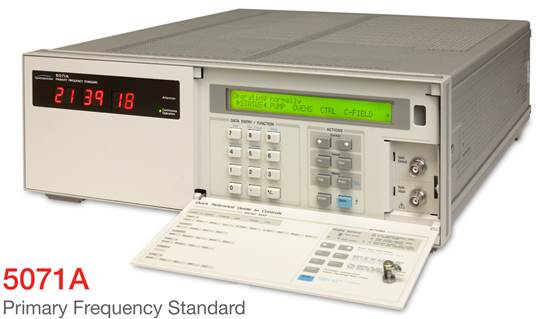
Responsibility for civil time was assumed by the National Standards Commission in 1993. By arrangement with the National Standards Commission, however, Nat Map’s later organisational identity maintained a defacto primary time standard as from 1 January 1994. The national physical standard, known as UTC (AUS), was kept by a small suitcase size Hewlett Packard 5071A caesium standard (please refer to the 5071A image above) at the Orroral Observatory until 1 September 1998. Under its agreement with the National Standards Commission, UTC (AUS) had been maintained to within 1 microsecond of UTC (BIPM) at all times. In 1998 however, when Nat Map’s Orroral facility was closed Nat Map formally ceased any role in the keeping and dissemination of Australia’s time.
More detailed information on the National Time Service and National Mapping’s 1983 Technical Report 32, Construction and comparison of Atomic Time Scale Algorithms : with a brief review of time and its dissemination, by John McK Luck, may be accessed via the hyperlinks.
the Photographic Zenith Tube (PZT) at Mount Stromlo
For most of the 20th century time was kept by observatory clocks, which were adjusted by astronomical observations. This procedure provided a comparison between the standard clocks of the observatory and the Earth itself, regarded as a clock, but the comparison was affected by the errors inherent in the time determinations. Even the high precision of the quartz crystal oscillators required high accuracy in the astronomical time determinations for them to provide an effective control of the clocks and particularly of their frequency drifts. By the mid 1950s, the conventional method of determining time by using a small transit instrument, with an impersonal micrometer (either hand driven, or driven by motor at a speed appropriate to the declination of each star), did not provide the high accuracy required for precision time keeping.
Sir George Biddell Airy (1801-1892) was the Astronomer Royal from 1835 to 1881 (the Astronomer Royal is a position in the British royal household that dates from 1675). In 1854, Airy designed a reflex zenith tube. In October 1911, the first Photographic Zenith Tube designed by Dr Frank Ross became operational at the United States Naval Observatory in Washington DC. This instrument kept Airy’s basic optical and mechanical principles with added technological refinements. In 1934 after a number of experiments the Naval Observatory in Washington determined time with this photographic zenith tube. In 1949 a second more advanced Photographic Zenith Tube commenced operations at Richmond (near Miami) in Florida. The significant advantage of the Photographic Zenith Tube was that no human observer was involved. With the telescope’s zenith view of the night sky being photographed, the problem of the human observer’s personal equation was eliminated.
Photographic Zenith Tube observations were able to provide the most precise means for determining the position of a point on the Earth's surface with respect to the celestial sphere at a given epoch. As the coordinates of the stars were known, the analysis of the zenith observations determined; the angular rotation error of the Earth relative to that of a uniformly rotating body, and the changes in the angular distance between the instrument and the instantaneous pole of rotation. These two quantities were more simply defined as determination of Universal Time, and Variation of Latitude.
In a 1949 lecture, The Royal Greenwich Observatory, the Astronomer Royal described a photographic zenith tube, which was expected to reduce the probable error of a time determination to a few milliseconds, was then in an advanced stage of construction. This new instrument, based on Airy's design of the reflex zenith tube at Greenwich, would incorporate modifications to permit photographic observation. These modifications were to be similar to those Frank Ross designed into the photographic zenith tube in Washington. The fundamental addition was to employ mercury to reflect the incoming light and to focus it such that any observations would be largely independent of any error in the instrument’s level.
The Astronomer Royal indicated that the advantages of this type of instrument for time determination were considerable. The observations being photographic, eliminated personal equations in the observations. As mentioned above, dislevelment was eliminated; there was no collimation correction necessary; observations in the zenith were now completely independent of azimuth error. As the instrument was fixed, the various sources of error applicable to a moving instrument, could not occur. A longer focal length could be used which was not possible with a moving instrument, with the advantage of a correspondingly greater scale. Observations were restricted to the zenith, where atmospheric transparency was highest and refraction effects were minimised.
In comparison with the Washington instrument, the Greenwich designed photographic zenith tube, would have :
|
- |
a larger aperture (10 inches) and longer focal length (135 inches). |
|
- |
the time scale would be produced photographically by means of a clock controlled lamp giving flashes of very short duration; an independent chronograph was not required. |
|
- |
the height of the mercury surface was to be accurately adjustable thus maintaining a constant scale value. |
In addition to the above, a number of essentially mechanical improvements would ensure its moving parts operated more accurately, smoothly and with greater reliability.
Around the mid 1950s it was reported that:…an instrument [Photographic Zenith Tube], embodying the same principles, but whose design differs in almost every detail from the Washington design has been under construction for some years for the Greenwich Observatory and is now almost completed. In this design, which is somewhat elaborate, an attempt has been made to keep every possible source of instrumental error within extremely narrow limits. The errors of the time determinations with this instrument will be due almost entirely to causes outside the telescope, which are associated with the meteorological conditions at the times of observation. Within the course of the next few years several other photographic zenith tubes are likely to be brought into use. The Cantonal Observatory, Neuchatel, and the Commonwealth Observatory, Mount Stromlo, have ordered from Grubb Parsons and Company zenith tubes which are a somewhat simplified version of the Greenwich design. The Dominion Observatory, Ottawa, has a zenith tube under construction by Canadian Vickers. A Photographic Zenith Tube is being built for the Tokyo Observatory.
Photographic Zenith Tube, manufactured in 1954 and destined for Mount Stromlo, being tested in England (courtesy Grubb Parsons).
From 1971 to 1985 the Mount Stromlo Photographic Zenith Tube was managed and operated by staff of Nat Map’s Astro-Geodetic Observatories Section, later Branch. It was seen as an outpost of the Orroral Astro-Geodetic Observatory and its work played an important role in the maintenance of time. As mentioned above, the Photographic Zenith Tube was brought into regular use at the Mount Stromlo Observatory from March/April 1957. It had been anchored to its bedrock base on the mountain in the preceding months. Soon after the Photographic Zenith Tube was commissioned it was reported that:…In keeping with the reliability of the set of clocks controlled by quartz oscillators, a photographic zenith tube has recently been installed with which more precise determinations of astronomical time can be made than through visual meridian transit observations. Although the Photographic Zenith Tube can record transits only of stars within 15' of the zenith, its 10 inch objective lens permits the selection of much fainter stars than those previously observed visually.
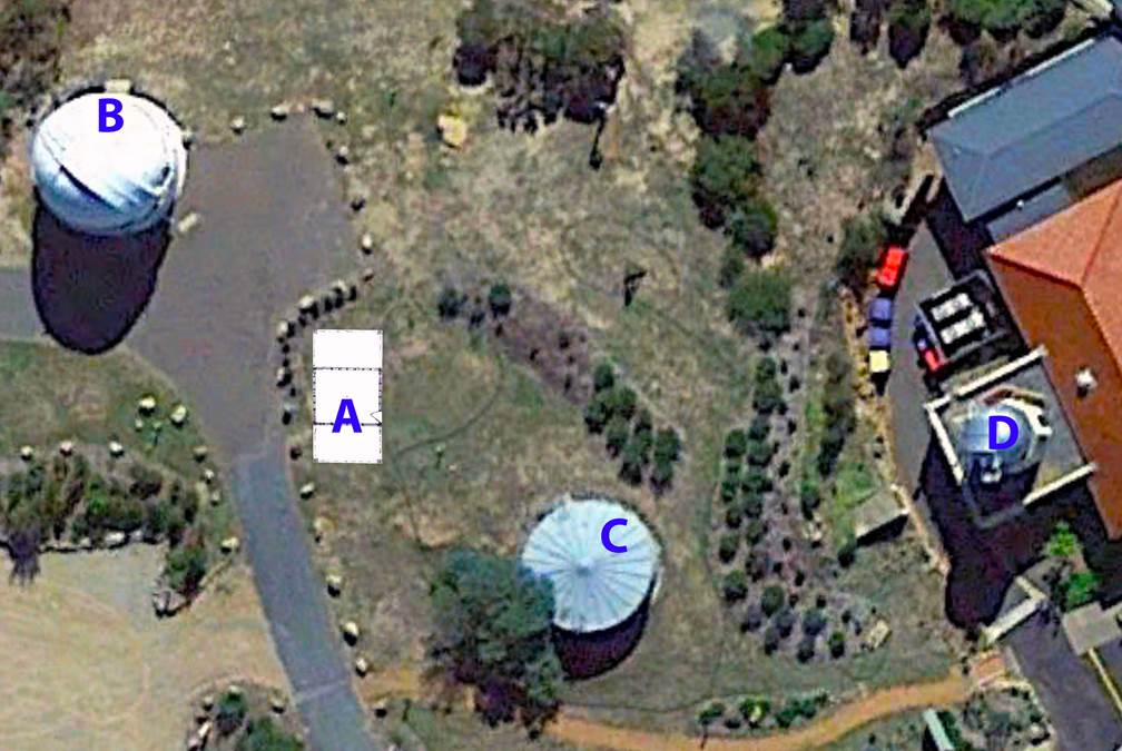
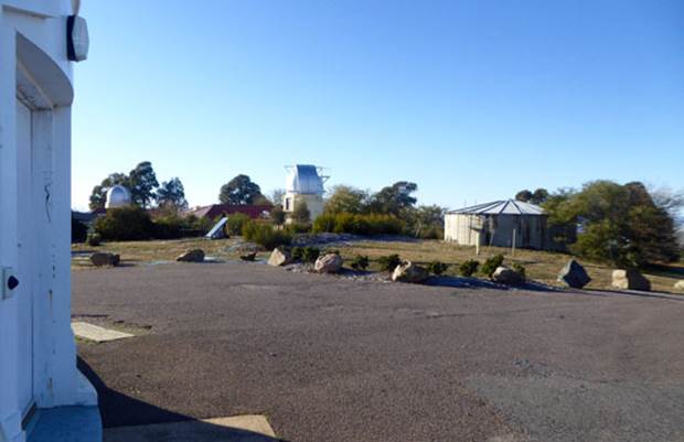
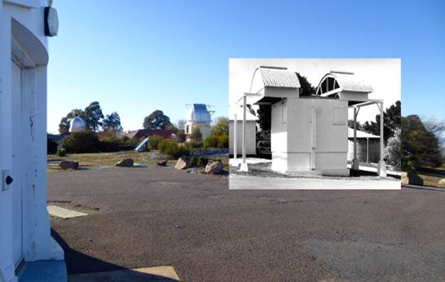
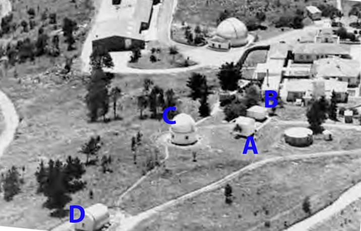
Google Earth Image 2019 with plan of Photographic Zenith Tube site (A) located at scale from original survey data and showing Reynolds Reflector (B), water tank (C) and Farnham Dome (D); below left is the June 2019 view from the Reynolds Reflector to the water tank and Farnham Dome in the centre background and right is the same view with the Photographic Zenith Tube hut superimposed showing how it would have appeared (2019 photograph courtesy Rod Menzies).
Not long after its 1971 transfer to Nat Map, mechanical problems with the Photographic Zenith Tube rotation mechanism and deterioration of electrical components, led to Nat Map temporarily suspending Photographic Zenith Tube operations on 3 November 1975. The rotation mechanism and electrical components were sent to England for repair. During this time the 10 inch lens was sent to be recoated; an unfortunate incident during this process meant that the work on the lens took much longer than planned. Following refurbishment, Photographic Zenith Tube operations recommenced in July 1977. While the Photographic Zenith Tube was being refurbished a review of the data collected since 1957 was undertaken. On completion the review provided a continuous record of the 4,620 plates, containing an average of 15 stars per plate, Eastman Kodak Spectroscopic Plates (Type IIa-O) being the photographic media. The plates were glass, 41 x 41 millimetres square and 0.04 inches thick and came in boxes of 36. New software facilitated the data reduction and retrieval. 1977 also saw the Mount Stromlo Photographic Zenith Tube, as one of six such instruments in the world, recognised for having accumulated earth rotation and polar motion data over a full nutation (cyclical movement of the axis of rotation) period of 18.61 years (6 798 days). The precision of observations from the Photographic Zenith Tube was 14 milliseconds of time and 0.14 arc seconds of latitude per star, equivalent to a circle about 1.5 metres in diameter.
The 1976 Photographic Zenith Tube downtime was also used to make modifications and automate the opening of the roof of the Photographic Zenith Tube hut at Mount Stromlo. The semicylindrical roof opened like a pair of sliding doors, each half of the roof sliding in opposite directions to make an opening. Initially this had been done manually.
The last plate observed by the Mount Stromlo Photographic Zenith Tube was on 27 August 1985. In September 1985, Nat Map ceased operation of the Photographic Zenith Tube as by now laser ranging had been proven to produce superior results. This outcome now fulfilled one of the initial benefits foreseen in locating laser ranging operations in close proximity to the Mount Stromlo Photographic Zenith Tube. When the Photographic Zenith Tube became obsolete in 1985 the Positional Astronomy Section was part of the Astro-Geodetic Observatories Branch within Nat Map’s Survey Group. The Astro-Geodetic Observatories Section having been first formed in 1982.
National Mapping’s 1973 Technical Report 15, Photographic Zenith Tube Observations at Mount Stromlo, by Malcolm John Miller, details the Photographic Zenith Tube and its operation. Photographs may be viewed via this link.
The Mount Stromlo Photographic Zenith Tube now resides with Museums Victoria at their Moreland Annex. The Photographic Zenith Tube itself is registered as HT7183, the controller module is HT7552 and various other mechanical, photographic and electronic parts and spares are also registered. At the time of writing this article, the unit was not assembled and was not accessible.
Principle of the Photographic Zenith Tube
A Photographic Zenith Tube was a vertical tube with a lens at its upper end and a mercury mirror at the lower end. Please refer to the schematic diagrams below. The light rays which passed through the lens were reflected back by the mercury mirror and the image was formed on a photographic plate borne by a carriage rigidly connected to the lens frame. The photographic plate was located at the lower nodal point of the objective lens so that the position of the image of the zenith in the field of view was not affected by a tilt or a horizontal shift of the lens. The carriage motion was controlled in such a way that a star image remained fixed on the photographic plate. While moving, the carriage triggered timing pulses. The upper portion of the instrument, called the rotary and including the lens and the plate holder on its carriage, could be rotated on ball bearings through 180°. This reversal caused the image to appear on the opposite side of the field, whereas the image of the zenith was not affected.
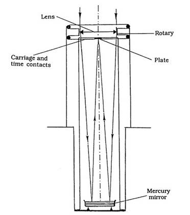
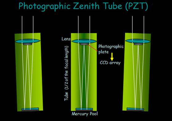
Schematic of a Photographic Zenith Tube (top) and below it a diagram showing how the mercury pool eliminated any minor dislevelment of the Photographic Zenith Tube and in modern Photographic Zenith Tube’s the photographic plate has been replaced by a light sensitive array as in digital cameras.
Operationally a star (in practice all stars in the field of view) was photographed four times on the same plate during its transit. While the star was east of the meridian it was photographed in the normal position (S1) of the rotary, and then in the 180 degree reversed position (S2) as shown in the diagrammatic representation below. Then when the star had crossed the meridian, it was first photographed in the reversed position of the rotary (S3), then after a 180 degree rotation, back in the normal position (S4). The mean epoch times of the four consecutive exposures may be considered as t1, t2, t3, and t4. The images of the star were measured such that Xi, Yi (for i = 1, 2, 3, 4) were their positions in a system of coordinates centred at the image zenith (Z), the ZX axis being parallel to the motion S1S4 or S2S3 of the star image.
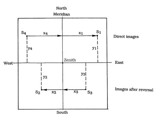
Diagrammatic representation of a Photographic Zenith Tube plate showing the positions of a star before and after transit and before and after 180 degree reversal.
Then, at time (t1 + t4) / 2, the position of the star image is (X1 + X4) / 2, or, in the sky, the hour angle was
H = (f /2V)*(X1 - X4),
where f is the scale factor of the tube and V is the transit speed of the image.
Using the four exposures, at time (tm) where
tm =
(t1 + t2 + t3 + t4) / 4,
the hour angle (Hm) of the star was
Hm = (f
/4V)*(X1 - X4 + X3 - X2)
Similarly, the zenith distance (zm) was
zm = (f
/4V)*(Y1 - Y4 + Y3 - Y2 )
Calibrations were performed to find the scale factor f. In addition, the path of the star was not linear but was the gnomonic projection of a celestial parallel. A correction was applied to remove the curvature resulting from this projection. The precision of a Photographic Zenith Tube was about 0.2” in zenith distance and 0.05” in hour angle.
The Mount Stromlo Photographic Zenith Tube - the Origin for Australian Longitude, 1962-1985
As described in Tony Bomford’s 1967 paper The Geodetic Adjustment of Australia, 1963-1966, the Photographic Zenith Tube became integral to the definition of the Australian National Spheroid (ANS) as the basis for the Australian Geodetic Datum (AGD66). The centre of the ANS was the ground mark at the Johnston Geodetic Origin. The orientation of the Australian National Spheroid was then defined by having its minor or polar axis and the earth's mean axis of rotation, at the start of 1962, being parallel (parallel with respect to the solid earth; with respect to the stars, both the earth and its axis change direction due to precession and nutation). The origin for the Johnston Geodetic Origin longitude, 133° 12’ 30.0771” east, and indeed all longitudes in Australia, was then defined as that of the Photographic Zenith Tube at Mount Stromlo. In turn, the longitude of the Photographic Zenith Tube at Mount Stromlo was established as being 149° 00’ 18.855” east of the longitude of the Bureau International de l'Heure mean observatory, commonly known as Greenwich. The orientation and position of the Australian National Spheroid was thus defined nationally and internationally. By default, defining the longitude of the Photographic Zenith Tube in relation to Greenwich, the time difference between the two locations was established allowing the time set in Australia to be accurately converted to then Universal Time, previously known as Greenwich Mean Time.
Within the Photographic Zenith Tube, it was the lower nodal point which was the instrument’s physical origin. As mentioned above the photographic plate was located at the lower nodal point of the objective lens so that the position of the image of the zenith in the field of view was not affected by a tilt or a horizontal shift of the lens. It was this point, represented by the zenith point on the photographic plate, to which all star measurements were related. The nodal point was connected by survey measurements to the Australian geodetic network and formed one of the points coordinated in the geodetic adjustment of 1966 (AGD66). The lower nodal point, and hence the Photographic Zenith Tube, was thus determined to be 149° 00’ 18.855” east of the longitude of the Bureau International de l'Heure mean observatory.
The International Astronomical Union (IAU) and the International Union of Geodesy and Geophysics (IUGG) in 1967 adopted the Conventional International Origin (CIO). The CIO was defined as the mean direction of the (north) pole determined by measurements of the five International Latitude Service (ILS) stations during the 5 year period 1900.0 to 1906.0 (the five ILS stations were Mizusawa, Japan; Carloforte, San Pietro Island, Italy; Gaithersburg, Maryland and Ukiah, California both in the USA; Kitab, today a town in Kitob District of Qashqadaryo Region in Uzbekistan, during the Soviet period, a major astronomical observatory was built at Kitab to commemorate its medieval reputation as the town of astronomers). Although this definition of the CIO was somewhat cumbersome it helped to preserve continuity with the long record of optical polar motion determinations which began formally in 1899 with the establishment of the ILS.
The BIH reference pole was adjusted to the CIO pole in 1967. In furtherance of this international change, the National Mapping Council of Australia resolved (Resolution 333 of 1969) to also adopt the CIO for all astronomical observations in Australia and its Territories, as from 1 January 1968. In terms of the existing AGD66 and the later AGD84 this change made no difference for all practical purposes other than that in the definition of the spheroid, where the reference to the BIH was replaced with the CIO. The CIO was then kept stable independently until 1987. In 1982 a new national adjustment computation was performed to improve the accuracy of the AGD66 coordinate set. It used the Australian National Spheroid (ANS) and incorporated all previous data as well as additional terrestrial and space based Transit Doppler observations. This adjustment corrected a number of deficiencies in AGD66 and also included geoid-ellipsoid separations, which had previously been assumed to be zero in the 1966 adjustment. The resultant coordinate data set was accepted by the National Mapping Council in 1984 and was known as the Australian Geodetic Datum 1984 (AGD84).
The International Earth Rotation Service (IERS) succeeded the BIH in 1988. From then on, the International Terrestrial Reference Frame (ITRF) was adopted whereby a set of points with their 3 dimensional cartesian coordinates realised an ideal reference system. The first ITRF was released in 1989 (ITRF89) and the latest release was ITRF2014.
The Nat Map Orroral Astro-Geodetic Observatory Heritage Listed
At its meeting of 2 June 2016, the ACT Heritage Council decided to register the obsolete Nat Map Orroral Astro-Geodetic Observatory.
The following was part of a media article, which read :
|
Historic Canberra bus shelters and rare geodetic observatory heritage listed By Denholm Samaras. Posted 10 Jun 2016, 11:51am Inner Canberra's timber bus shelters and an isolated observatory that once provided Australia with its official time have been added to the ACT's heritage register. The ACT Heritage Council said the antiquated bus shelters and the decommissioned Orroral Observatory were placed on the list to ensure they remained for generations to come. Observatory was one of two of its kind in southern hemisphere
Photo: The Observatory enabled the measurements of the Earth's shape within millimetres of accuracy. (ABC News: Supplied) The Orroral Observatory, located past Tharwa about 60 kilometres south of the Canberra CBD was named after the local Indigenous word 'Orongo' meaning 'tomorrow'. "This is a very interesting one, for a long time it was Australia's fundamental geodetic facility," Dr Jaireth said. "It provided Australia with its official time." The Orroral Observatory was highly functional, it enabled the measurements of the Earth's shape within millimetres of accuracy." The data the observatory gathered helped to confirm plate tectonics theory and informed international research on natural phenomena and disasters.
What’s left on the ground floor! "It was only one of two geodetic observatories in the southern hemisphere between 1974 and 1999, the only such facility in the ACT until its functions were transferred to the Mt Stromlo Observatory in 1999," Dr Jaireth said. |
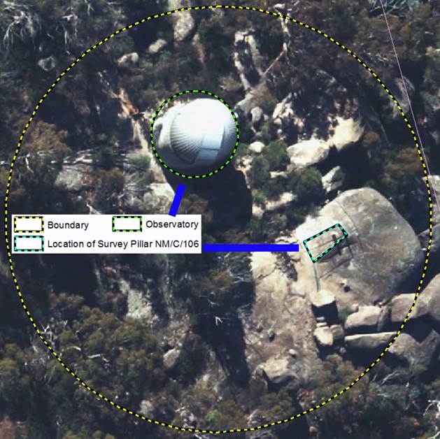
The Orroral Astro-Geodetic Observatory today, is described as a 9 metre diameter hemispherical dome surmounting a grey-brick cylindrical building and survey pillar NM/C/106 within a trapezoidal fenced area atop granite boulder, 22.6 metres south east of the observatory dome, is at the top of a ridge at the end of a trail, called the Granite Tors Walking Track. A plaque on survey pillar No.1, identified as NM/C/106, is inscribed Harry Granger Surveyor National Mapping 25-6-28 21-6-77 in recognition of Harry who passed away while on duty.
The ACT Heritage Council’s, Heritage (Decision about Registration of the Orroral Geodetic Observatory, Tennent) Notice 2016, can be read here in full. Other newspaper articles on Orroral and its closing (not always technically precise) are Matthew Higgins' Features Ancient and Modern Works of Man in the Orroral Valley, from page 16 of The Canberra Times newspaper of Sunday 2 January 1994 and from the National Parks Association (ACT) Incorporated, December Bulletin, Vol.36, No.4, pp.8-9, Graeme Barrow's 1999 article Space Explorers Quit Orroral.
Acknowledgement
The assistance of John Luck and Laurie McLean is gratefully acknowledged, as is Hannah Perkins, Collection Manager, Arts (Society & Technology), Moreland Annexe, Museums Victoria, for her provision of information on the Photographic Zenith Tube and Rod Menzies for his June 2019 Mount Stromlo site photographs enabling the locating of the Photographic Zenith Tube in the site today.
Original information courtesy John Manning and Bob Twilley, 2016; recompiled and expanded by Paul Wise, 2019.
|
|
|
|
Nat Map’s Orroral Astro-Geodetic Observatory in late 1990s |
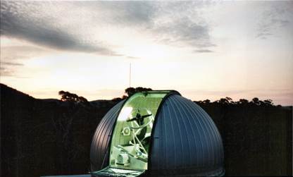
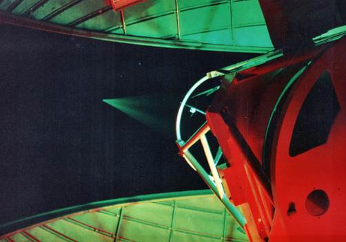
Dome opened for operations |
|
|
|
|
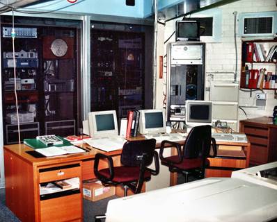
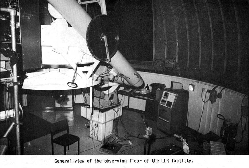
Observatory control room |
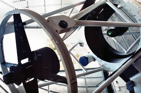
Laser ranging mirror assembly |
|
|
|
|
Laser pulse being emitted |
|
|
|
|
|
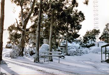
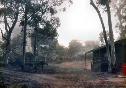
Orroral in winter snow and summer bushfire smoke |
|
|
Photographs courtesy Dave Abreu |
|
|
|
|
|
After Pearlman (1977) |
|
|
|
|
|
Orroral Astro-Geodetic Observatory and at left the collimation tower in early 1980s |
|
|
|
|
|
Laser optics early 1980s |
|
|
|
|
|
Laser Ranger Telescope early 1980s |
|
|
|
|
|
Survey pillar No.1, identified as NM/C/106, showing plaque inscribed Harry Granger Surveyor National Mapping 25-6-28 21-6-77 in recognition of Harry who passed away while on duty (courtesy ACT Heritage 2015). |
|
|
|
|
|
Survey pillar No.1, identified as NM/C/106, relative to the Orroral Astro-Geodetic Observatory (courtesy ACT Heritage 2015). |
|
|
|
|
|
Edited 1953 plans for the 10” Photographic Zenith Tube – Mount Stromlo; Note that the plans show that the Photographic Zenith Tube building is separated from the room to contain the controller console. (Courtesy National Archives Australia : Series A2617, SECTION 38/21900, Barcode 7238487) |
|
|
|
|
|
|
|
|
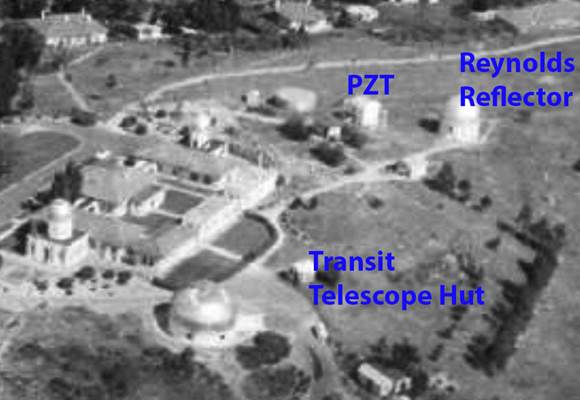
Circa late 1950s aerial overview showing the Transit Telescope and Photographic Zenith Tube huts at Mount Stromlo; the location of the Reynold’s Reflector is indicated for reference (after GML Heritage, 2015). |
|
|
|
|
|
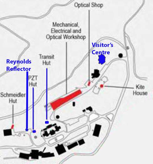
Section of 2015 map showing existing structures in black with removed structures in red and in blue the Transit Telescope and Photographic Zenith Tube huts in relation to the Reynold’s Reflector (after GML Heritage, 2015). |
|
|
|
|
|
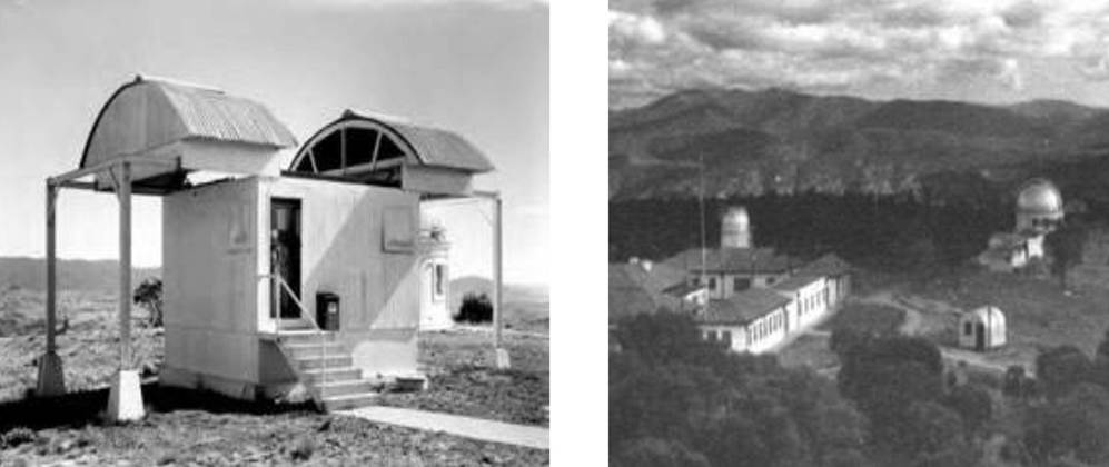
(Left) Photographic Zenith Tube hut, circa late 1950s, with roof open and the Photographic Zenith Tube just visible through the open door; at right side of Photographic Zenith Tube hut, mostly obscured, is the Reynold’s Reflector; (right) Transit Telescope hut with curved roof at lower right, circa early 1950s (after GML Heritage, 2015). |
|
|
|
|
|
1970 aerial overview showing the (A) Photographic Zenith Tube and (B) control huts at Mount Stromlo; the locations of the (C) Reynold’s Reflector and (D) Schmeidler Hut are indicated for reference (after GML Heritage, 2015). |
|
|
|
|
|
Left 1962 photograph shows staff member loading the plate holder containing a glass photographic plate into the Mount Stromlo Photographic Zenith Tube prior to operations (courtesy National Archives Australia : Series A1200, L42631, Barcode 8832462); right 1956 photograph is the Photographic Zenith Tube control rack destined for Mount Stromlo after construction in England (courtesy Grubb Parsons). |
|
|
|
|
|
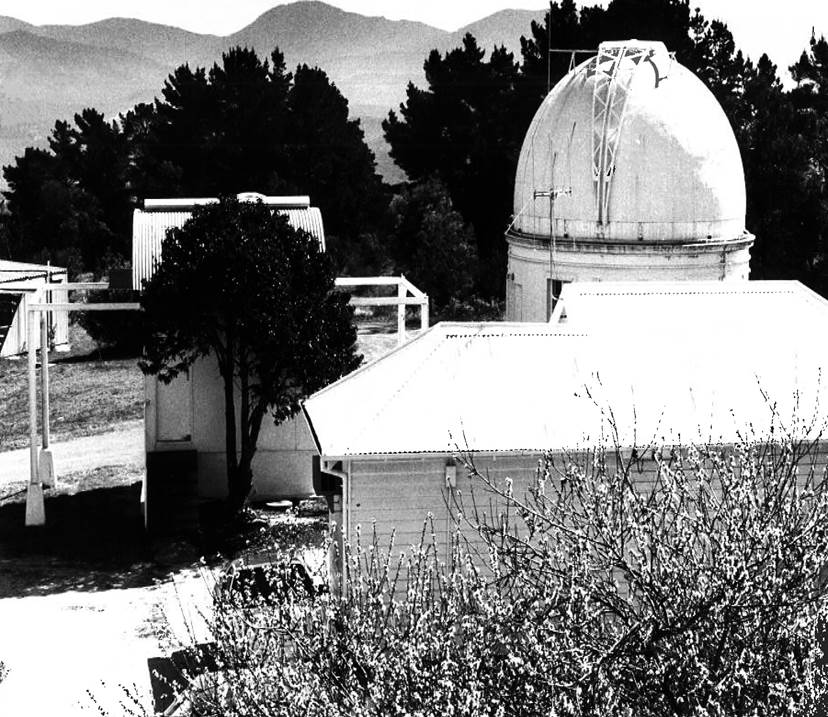
January 1990 photograph looking west, showing the Photographic Zenith Tube control hut in the foreground with the Photographic Zenith Tube hut centre left and rear right the Reynold’s Reflector (XNATMAP Image). |
|
|
|
|
|
When the National Time Service was at Mount Stromlo |
|
|
|
|
|
(Left) Troughton & Simms 8 inch Transit Telescope at the Melbourne Observatory (after Andropoulos, 2014); (Right) Charles Frodsham, eight day, long case, astronomical regulator clock as used at the Melbourne Observatory for operating the Victorian time service; later such a clock type went to Mount Stromlo. |
|
|
|
|
|
1954 photograph of clocks at Mount Stromlo. |
|
|
|
|
|
Claire Wehner adjusting for the Time Service 1950s (courtesy Mt Stromlo Archives : https://services.anu.edu.au/campus-environment/trails-tours/mt-stromlo-heritage-trail/the-other-lives-of-stromlo). |
|
|
|
|
|
|
|
|
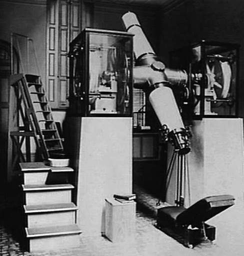
The above photograph is understood to show the Mount Stromlo 3 inch Transit Telescope in use. The telescope was housed in a wooden building erected in the 1940s and later removed in the early 1960s, probably when the facility was replaced by the more accurate and versatile Photographic Zenith Tube. |
|
|
|
|
|
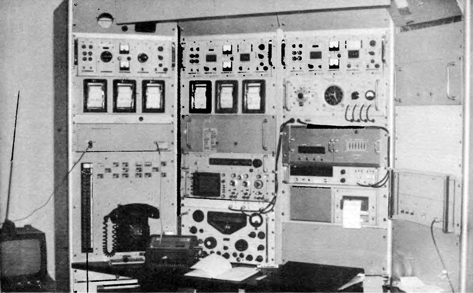
Mount Stromlo Time Service Equipment circa 1972 |
|
Sources
Andropoulos, Jenny Ioanna (2014), Astronomical Publications of Melbourne Observatory, PhD thesis James Cook University, accessed at : https://www.google.com/url?sa=t&rct=j&q=&esrc=s&source=web&cd=1&cad=rja&uact=8&ved=2ahUKEwiR9OG219biAhVOSX0KHQ1QCRwQFjAAegQIBBAC&url=https%3A%2F%2Fresearchonline.jcu.edu.au%2F41296%2F1%2F41296-andropoulos-2014-thesis-volume-1.pdf&usg=AOvVaw0T6ZLhyi-C28ZF7ly4HVWe
Anonymous (1944), Our Observatory : Tasks to end in June, The Herald, Melbourne: 1861 – 1954, Tuesday 26 December 1944, pp.3, accessed at TROVE : https://trove.nla.gov.au/newspaper/article/246016814
Anonymous (1944), New Marvels to Benefit Radio, Maryborough Chronicle, Wide Bay and Burnett Advertiser: 1860 – 1947, Wednesday 27 December 1944, pp.2, accessed at TROVE : https://trove.nla.gov.au/newspaper/article/151407940
Anonymous (1946), Commonwealth Observatory's Role in Atomic Studies, The Canberra Times, ACT: 1926 – 1995, Friday 31 May 1946, pp.2, accessed at TROVE : https://trove.nla.gov.au/newspaper/article/2684407
Anonymous (1946), Seconds Cut in Time Service, The Courier-Mail, Brisbane: 1933 – 1954, Friday 31 May 1946, pp.4, accessed at TROVE : https://trove.nla.gov.au/newspaper/article/50281067
Anonymous (1954), Tenders Called, Construction, Sydney: 1938 - 1954, Wednesday 16 June 1954, pp.17, accessed at TROVE : https://trove.nla.gov.au/newspaper/article/224516315
Anonymous (1957), Geophysical Year Role for Stromlo, The Canberra Times, ACT: 1926 – 1995, Tuesday 2 July 1957, pp.3, accessed at TROVE : https://trove.nla.gov.au/newspaper/article/91592470
Anonymous (1986), OBITUARY: H. J. M. ABRAHAM, The Canberra Times, ACT: 1926 – 1995, Thursday 2 January 1986, pp.6, accessed at TROVE : https://trove.nla.gov.au/newspaper/article/122424183
Barrow, Graeme (1999), Space Explorers Quit Orroral, National Parks Association (ACT) Incorporated, December Bulletin, Vol.36, No.4, pp.8-9.
Bomford, Anthony Gerald (1967), The Geodetic Adjustment of Australia, 1963-1966, Survey Review, Vol.XIX, No.144, pp.52-71, accessed at : http://xnatmap.org/adnm/ops/prog/rafgeosvy/geodadj/geodadj.htm
Boucheron, Pierre H (1986), Effects of the Gravitational Attractions of the Sun and Moon on the Period of a Pendulum, Antiquarian Horology (JM Plowman (Ed.)), Vol.16, No.1, pp.53-65, accessed at : https://www.google.com/search?client=firefox-b-d&q=Pierre+Boucheron+shorrt+clocks
Bryant, Robert J and Guilfoyle, John P (1984), An Overview of the NLRS Ranging Software, Fifth International Workshop on Laser Ranging Instrumentation, Royal Greenwich Observatory, Herstmonceux Castle Sussex UK, 10-14 September 1984, pp.384-395, accessed at : International Laser Ranging Service.
Buscombe, William (1958), Research at the Mount Stromlo Observatory, Journal of the Royal Astronomical Society of Canada, Vol.52, No.2, pp.68-81, accessed at : http://adsabs.harvard.edu/abs/1958JRASC..52...68B
Cannon, AH (1945), The Victorian Time Signal Service, The Telecommunication Journal of Australia, June 1945, pp.215-222.
Division of National Mapping (1971-1985), Statement of Activities, Division of National Mapping, various years.
Engineering Heritage Australia (2018), Mount Stromlo Nomination, accessed at : https://www.google.com/url?sa=t&rct=j&q=&esrc=s&source=web&cd=19&cad=rja&uact=8&ved=2ahUKEwio1P3YrPTiAhWHeisKHSuMD4g4ChAWMAh6BAgHEAI&url=https%3A%2F%2Fwww.engineersaustralia.org.au%2Fportal%2Fsystem%2Ffiles%2Fengineering-heritage-australia%2Fnomination-title%2FHRP.Mount%2520Stromlo.Nomination.V7.%2520Jan%25202018.pdf&usg=AOvVaw3D9psmlAZ6yfx6f7dxmqvD
Field, RH (1954), The Measurement of Time Intervals, National Mapping Bulletin by the National Mapping Council, Vol.6, No.1, April 1957, extracted from The Canadian Surveyor, July 1955.
Gascoigne, Sidney Charles Bartholemew (Ben) (1984), History of Australian Astronomy : Astrophysics at Mt Stromlo - the Woolley Era, Proceedings of the Astronomical Society of Australia, Vol.5, Iss.4, pp.597-605, accessed at : http://adsabs.harvard.edu/abs/1984PASAu...5..597G
Greene, Benny A (1984), Further Development of the NLRS at Orroral, Fifth International Workshop on Laser Ranging Instrumentation, Royal Greenwich Observatory, Herstmonceux Castle Sussex UK, 10-14 September 1984. pp.98-101, accessed at : International Laser Ranging Service.
Greene, Benny A (1984), Epoch Timing for Laser Ranging, Fifth International Workshop on Laser Ranging Instrumentation, Royal Greenwich Observatory, Herstmonceux Castle Sussex UK, 10-14 September 1984, pp.247-250, accessed at : International Laser Ranging Service.
Greene, Benny A and Visser, H (1984), Spectral Filters for Laser Ranging, Fifth International Workshop on Laser Ranging Instrumentation, Royal Greenwich Observatory, Herstmonceux Castle Sussex UK, 10-14 September 1984, pp.240-246, accessed at : International Laser Ranging Service.
GML Heritage Pty Ltd (2015), The Mount Stromlo Observatory Precinct Heritage Management Plan - Volume 1, Report prepared for the Australian National University (ANU), July 2015, accessed at : https://www.google.com/search?client=firefox-b-d&q=GML+stromlo+heritage
Grubb Parsons (1956), Astronomical Instruments, (1956), Sir Howard Grubb Parsons & Company Ltd, England, Publication 17, Ref.A.10.56, Andrew Reid & Co Ltd.
Jones, Harold Spencer (1949), The Royal Greenwich Observatory, Proceedings of the Royal Society London, 15 August 1949, Vol.198, pp.141-169, accessed at : http://www.geomag.bgs.ac.uk/data_service/data/yearbooks/ARpdf/AR_00825.pdf
Kovalevsky, Jean (1995), Modern Astrometry, Springer-Verlag, Berlin, accessed at : https://books.google.com.au/books?id=Qwb9CAAAQBAJ&pg=PA187&lpg=PA187&dq=principle%2Bof%2Bthe%2Bphotographic%2Bzenith%2Btube&source=bl&ots=O_lQrgaP5k&sig=ACfU3U2tV7_v8rTW6UbqXiefrvEkzCtjmA&hl=en&sa=X&ved=2ahUKEwj2iIKcl_LiAhXUdCsKHYCWAEoQ6AEwC3oECAkQAQ#v=onepage&q=principle%2Bof%2Bthe%2Bphotographic%2Bzenith%2Btube&f=false
Laud Peter (1967), Stromlo’s room No.3 is on time, The Canberra Times Newspaper, ACT, Saturday 5 August 1967, pp.7, accessed at : https://trove.nla.gov.au/newspaper/article/106970428?searchTerm=time%20stromlo&searchLimits=l-availability=y|||l-australian=y|||l-title=11|||l-category=Article|||l-decade=196|||l-year=1967
Luck, John McK (1983), Construction and comparison of Atomic Time Scale Algorithms : with a brief review of time and its dissemination, Technical Report 32, Division of National Mapping.
Luck, John McK (c1995), Performance of the Upgraded Orroral Laser Ranging System, publication details unknown.
Luck, John McK (2019), Personal Communications.
Luck, John Mck, Miller, Malcolm John, Morgan, Peter J (1973), The National Mapping Lunar Laser Program, Proceedings Symposium on Earth's Gravitational Field and Secular Variations in Position, UNSW.
Luck, J McK, Harvey, I K, Harris, R W, Harvey, G (late 1980s), Status of Activities and Plans for Precise Time Comparisons in Australia, publication status unknown.
Lyons, Harold (1958), Atomic Clocks, Scientific American, accessed at : https://tf.nist.gov/general/pdf/1568.pdf
McLean, Lawrence William (2019), Personal communications.
Menzies, Roderick William (2019), Personal Communications.
Miller, Malcolm John (1973), Photographic Zenith Tube Observations at Mount Stromlo, Technical Report 15, Division of National Mapping.
Pearlman, Michael R (1977), Support of Lunar Laser Ranging System in Australia, prepared for National Aeronautics and Space Administration, Smithsonian Institution Astrophysical Observatory, accessed at : https://www.google.com/url?sa=t&rct=j&q=&esrc=s&source=web&cd=15&ved=2ahUKEwjet_HGjsziAhVWeH0KHSMQC-8QFjAOegQICBAC&url=https%3A%2F%2Fntrs.nasa.gov%2Farchive%2Fnasa%2Fcasi.ntrs.nasa.gov%2F19770075020.pdf&usg=AOvVaw2rNGUvHl-9KGsLqwJJdSt2
Perkins, Hannah (2019), Personal Communications (Hannah is Collection Manager, Arts (Society & Technology), Moreland Annexe, Museums Victoria).
Photographic Zenith Tube (2011), U.S. Naval Observatory (USNO) Photographic Zenith Tube, accessed at : https://bollerandchivens.com/?p=844
Simpson, GB (1974), [Rec1974_107.pdf] Lunar Laser Ranger Site, Orroral Valley, ACT : Foundation Investigation – 1974, Bureau of Mineral Resources, Geology and Geophysics, Department of Minerals and Energy, Record 1974/107, accessed at : https://www.google.com/url?sa=t&rct=j&q=&esrc=s&source=web&cd=1&ved=2ahUKEwje67CR_eziAhXMdn0KHezZAA8QFjAAegQIARAB&url=https%3A%2F%2Fd28rz98at9flks.cloudfront.net%2F13147%2FRec1974_107.pdf&usg=AOvVaw1BxZP_HVVOiYBDHQh4tmoe
Thomson, Malcolm M (1968), The Calgary Photographic Zenith Tube (P.Z.T.), Journal of the Royal Astronomical Society of Canada, Vol.62, pp.205-213, accessed at : http://adsabs.harvard.edu/full/1968JRASC..62..205T
Transactions of the International Astronomical Union (Oosterhoff, P Th. (Ed.)), (1954), Commission on Time, (1954), International Council of Scientific Unions, International Astronomical Union, Vol.VIII, Eighth General Assembly, Rome, 4 September to 13 September 1952, Cambridge at The University Press, accessed at : https://books.google.com.au/books?id=4IQ8AAAAIAAJ&pg=PA460&lpg=PA460&dq=zenith+tube+stromlo&source=bl&ots=8YmHEAJBxx&sig=ACfU3U1FGKt_5amvWkek7VDFPdeJxJbLhQ&hl=en&sa=X&ved=2ahUKEwjT18nk073iAhWLF3IKHZQSCGM4ChDoATABegQICBAB#v=onepage&q=zenith%20tube%20stromlo&f=false
Various reports (various), Photographic Zenith Tube at Mt Stromlo, Official Year Book of the Commonwealth of Australia.
Webster, John G (1999), The Measurement, Instrumentation, and Sensors : Handbook, CRC Press LLC, USA and Springer-Verlag Gmbh, Germany, accessed at : https://books.google.com.au/books?id=b7UuZzf9ivIC&pg=SA18-PA2&lpg=SA18-PA2&dq=Just+how+good+was+the+Shortt+Clock&source=bl&ots=wLUSXoPH03&sig=ACfU3U0eIkVpDyeVi56kwtLCZCg-QUuVpw&hl=en&sa=X&ved=2ahUKEwjm1MK7w8XiAhVaSX0KHZ49BfY4FBDoATAAegQIBRAB#v=onepage&q=Just%20how%20good%20was%20the%20Shortt%20Clock&f=false